
Background
The Miller Farm north of Rockwool was purchased by the land development company Jefferson Orchards, Inc. around the time they sold part of the old Jefferson Orchards land to Rockwool. In 2021 Jefferson Orchards, Inc. applied to have the land rezoned from Rural to Residential Growth. Residential Growth allows urban level housing development. Jefferson Orchards, Inc. was granted the zoning change even though it did not align with the 2035 County Comprehensive Plan. The Jefferson County Planning Commission and County Commission approved this zoning map amendment because they found that there had been major changes of an economic, physical or social nature within the area involved which were not anticipated when the comprehensive plan was adopted and those changes had substantially altered the basic characteristics of the area. State code requires (8A-7-8(a)) that such a substantial alteration be present if the zoning change is not consistent with the comprehensive plan. In this case the applicant and subsequently the Planning Commission and County Commission cited the extension of the new road – Northport Avenue – into the property to provide secondary ingress and egress from the community, so that not all of the traffic would be on Route 480. The applicant promised that the WVDOH would build this road to the site.
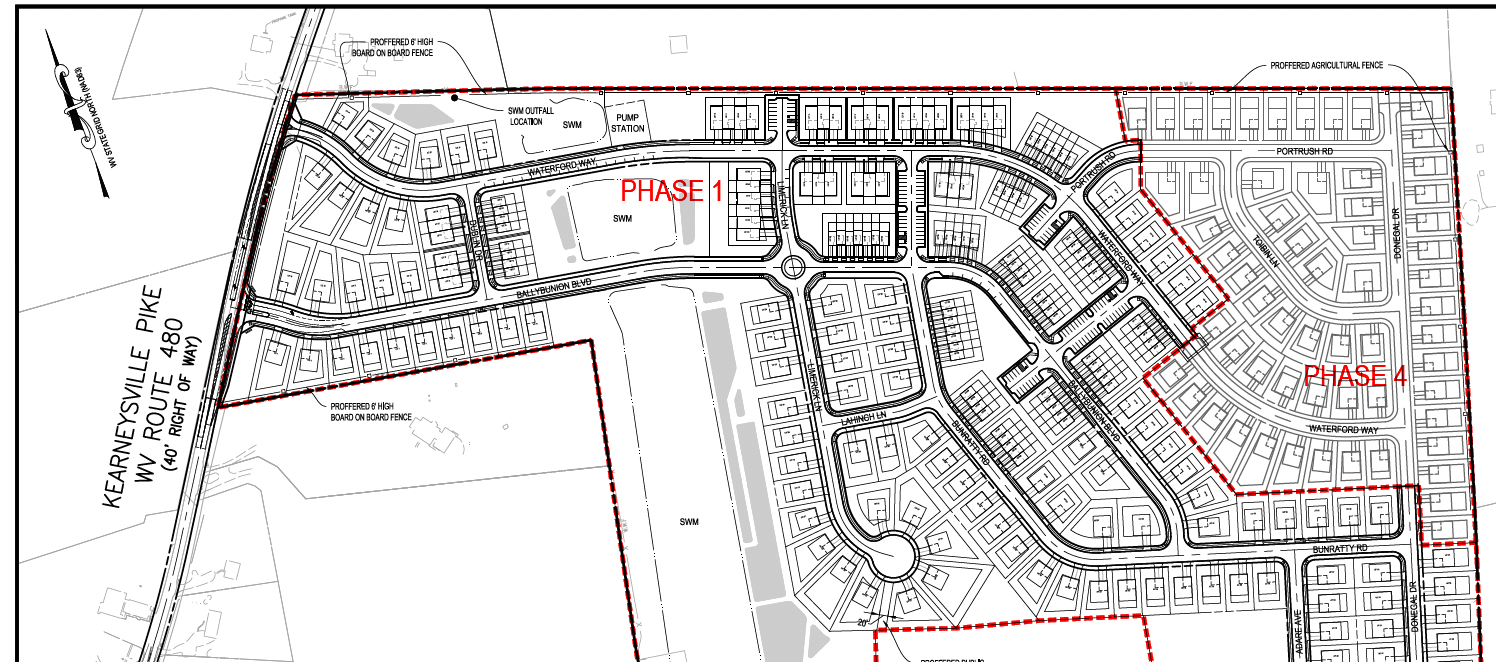
In May 2024, the applicant (Jefferson Orchards, Inc.) came back to the Planning Commission with a concept plan for a housing development—including 720 houses on 88.06 acres of lots, and tiny housing lots pushed right up against rural land where large livestock are kept and crop fields are planted. Frustratingly, when the applicant came back to the Planning Commission, they decided not to put in the road that had allowed the zoning change in the first place. The Planning Commission gave the applicant direction to continue to the preliminary plat stage and to meet with the adjoining land owners to address their concerns specifically with fencing to protect the adjoining land owners’ assets.
The owner, Jefferson Orchards, Inc., and the applicant, Lennar, came back with the preliminary plat in December 2024. At that time the application had major deficiencies including not having the NPDES permit, an insufficient historic resource impact study, and no phase 1 archaeological study.
What is happening
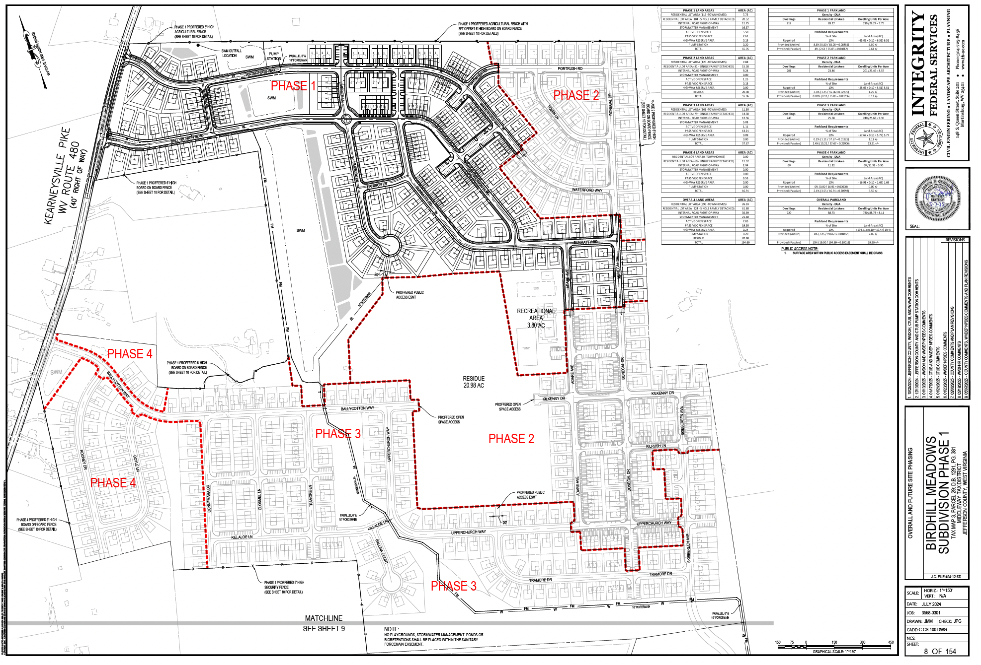
The developers of Birdhill Meadows Subdivision have applied for approval of a Preliminary Plat for Phase 1 of this development including 115 townhomes and 104 single family homes. The plat was approved and they are now applying for a Voluntary Remediation Plan.
Read the submitted Plat in this PDF (213MB PDF).
The Preliminary Plat issues
- There are zoning issues (24.113 D.1.). When the property was rezoned, Jefferson Orchards, Inc. promised that a road would be extended through the development from Northport Avenue to alleviate traffic issues on Route 480. The rezoning was in part based on this new road. The Planning Commission relied on this road to make a determination that there had been major changes of an economic, physical or social nature within the area involved which were not anticipated when the comprehensive plan was adopted and those changes have substantially altered the basic characteristics of the area. This determination is required by. State Code 8A-7-8a. However, now that the zoning has been changed the applicant has indicated they will not be building this road as part of this development.
When the applicant submitted the Concept Plan for this development it indicated that the road was no longer planned for the development. The applicant explained that they were concerned that industrial traffic would go through the housing development. This was a concern brought up by those who opposed the rezoning in 2021. The applicant received pushback from the Planning Commission for not building the road during the Concept Plan Public Workshop.
Now the Preliminary Plat shows a “Stage 5” of this development that includes a separate parcel zoned “light industrial.” This part of the development includes the road — the extension of Northport Avenue. Unfortunately, this means that all 720 houses could be built for years before this road was built. This was clearly not the intent that was expressed during the time of the rezoning request consideration. It appears that the zoning change may have been made in 2021 based on assertions that now may not be honored.
The development should not be allowed without this road. - 24.113. B.13. requires that applicants address the identified concerns from the Concept Plan. The Planning Commission directed the applicant to meet with the adjoining and confronting land owners regarding fencing prior to submitting the preliminary plat. This was not done. The company simply demanded that the adjoining landowners agreed to what the developer was offering.
The applicant needs to provide the fencing requested by the adjoining property owners. - The stormwater at the development is not adequate to protect groundwater quality. The massive stormwater ponds do not comply this the stormwater guidance documents for stormwater system design in karst in the Chesapeake Bay Watershed. See the stormwater section below for more details.
The ponds need to be lined with impervious 60mil liners not just compressed clay to prevent sinkhole formation, and the outlet needs to be redesigned to create sheet flow at the discharge location.
Stormwater issues
This development is located in a karst area of the county with a high sinkhole rate and such high bedrock permeability that it there are no surface streams. Currently all water that falls to the ground on this property during normal rainfalls immediately infiltrates into the groundwater.
This development is designed at urban level density. This density is allowed by the zoning but this has real consequences for the water resources in the surrounding rural zone and beyond.
While this development is in the Residential Growth Zone, which allows urban level density, it is nearly completely surrounded by the rural zone. All the residences and businesses (except Rockwool) in the surrounding area rely on well water for all uses including drinking.
This juxtaposition of urban level housing with rural and village properties on wells poses a water quality issue for the surrounding well users. The urban density community creates more stormwater pollution because there are more sources of pollutants (cars, people, houses) per acre than in a less dense development. The stormwater from this development is expected to have increased levels of petroleum contamination for example.
In higher population areas stormwater is required to be treated before it is discharged to protect the downstream user of the water. This is what is required in area’s designated MS4 (Municipal Separate Storm Sewer System). This high density development should be treated the same to protect groundwater users.
Most MS4 discharge into surface waters like rivers and that water is treated again before it is used for drinking. However, here the water will infiltrate with little treatment (a few bioretention basins) into the groundwater, which will be used by all surrounding properties in the county untreated. So, it is even more necessary that the stormwater from this location be treated before it is allowed to infiltrate.
In this case, it is not clear if all of the water from the development is being treated and the treatment of the water is insufficiently especially for times of increased rainfall. It is also not clear if the stormwater structures are appropriately designed for this area of advanced karst terrain.
The Karst Mitigation Plan is insufficient. While the Karst mitigation plan has some good features that protect the houses that are being built, it fails to protect the groundwater quality long term. All of the mitigation that has been added is to prevent damage to homes being built not to protect Groundwater quality.
The issues with the process
The Planning Department staff are refusing to post a public copy of the preliminary plat documents online for the public to view. They are also refusing to print a full-size copy of plans for members of the public to view in the Planning Commission office. The Subdivision Regulations require 21 days legal notice to the public before the public hearing. How can the public have a meaningful right to be heard if they do not have the opportunity to review the information? The planning commission staff needs to make the documents available to the public for review.
We found the preliminary plat posted at the Observer and have reposted it above.
The location and density of this development poses increased risk to groundwater quality. The very same water that is used untreated by all surrounding property owners in the county.
Current Project Status
The preliminary plat of phase 1 has been approved. The applicant now seeks to get a voluntary remediation plan approved at the WVDEP.
Birdhill Meadows Voluntary Remediation Plan
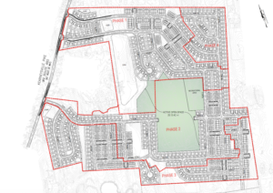
Have you wondered why the Birdhill Meadows development has the houses arranged in such an odd pattern? The Planning Commission did, and the developers’ representatives indicated that it was to save open space for the use of residents. Now that we see the voluntary remediation plan, it seems the developer specifically designed the layout to avoid placing houses on the portions of the property with the highest lead and arsenic contamination – and put the active open space recreational area there instead.
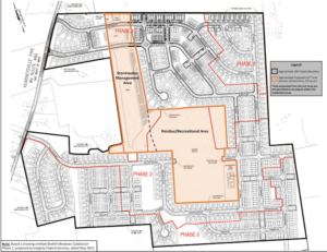
A central portion of the property was once an orchard, and has varying elevated levels of arsenic in this area. According to the concept plan, the affected areas will be used for stormwater structures and open space (active and passive).
The remediation consists of a land use covenant that limits exposure restricting the Stormwater Management Area and the Recreational/Residue Area from residential use, and also restricting the Stormwater Management Area from recreational use without further evaluation.
Click here to see the proposed Voluntary Remediation Plan.
The VRP issues
- When is the last time you checked a Land Use Covenant before you let your kids enjoy playing in a recreational area in a housing development – likely never! There needs to be permanent signage warning of the dangers and restrictions, and the developer should cap and cover the open space to protect future users.
- The stormwater ponds are not currently required to be lined with impervious plastic liners. They are only lined with clay. This means they will likely develop sinkholes just like the ones at two nearby developments. This is the location with the most arsenic contamination. We are concerned that a sinkhole in this location will cause arsenic groundwater contamination. The water from this location travels rapidly (outside of Shepherdstown in less than two weeks) in multiple directions possibly endangering the surrounding wells and well users. This risk should be mitigated by requiring the developer to install impervious plastic liners in the stormwater ponds.
What can you do?
Send public comment – we have made it easy. It will be sent automatically to WVDEP project manager Matt Gadd (william.m.gadd@wv.gov). Please add a personal comment in the note below. Public comments are due by January 31, 2026