
UPDATE
On June 3, 2021 the Jefferson County Commission approved the Zoning Map Amendment change for Jefferson Orchards by a vote of 4-1.
Tell the JCC to vote NO on Rezoning Amendment
What is happening?
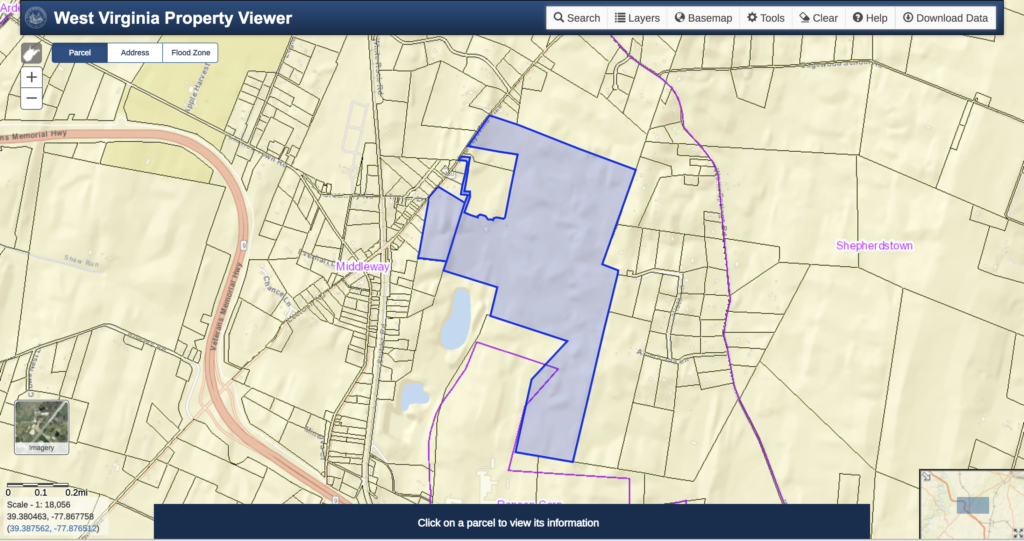
A zoning map amendment is currently under consideration by the Jefferson County Commission to be voted on at the June 3 meeting. This amendment seeks rezone two parcels in the county totaling 238.9 acres from Rural to Industrial and Residential.
The owner is seeking to have a 43.7 acre portion rezoned “light industrial.” The remainder of the land is to be zoned residential. The Northport Avenue road is to be extended out to 480 in two locations.
“Staff finds that the request is not consistent with the Future Land Use Guide of the 2035 Plan because it is designated as Future Rural/Agricultural and is outside any Preferred Growth Area (PGA) or Urban Growth Boundary.”
Read the full Planning Commission Staff Report
Why is this important?
The location to be rezoned industrial is highly environmentally sensitive. The groundwater at the site is readily contaminated and rapidly caries pollutants through the groundwater, surface waters, and into the Potomac effecting drinking water and the economy. This rezoning does not conform to the Comprehensive Plan, the County Zoning Ordinance, or the State Zoning regulations.
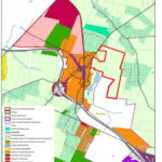
The area outlined in red shows the location of the parcels in question. This diagram shows that the area is currently zoned as Rural/Agriculture. The staff of the Planning Commission found that rezoning this parcel is not consistent with the Envision Jefferson 2035 Comprehensive Plan.
How does this tie in?
This is the next step in the spread of the heavy industry. In this case, the applicant argues the zoning should be changed because the zoning of the adjacent land in Ranson was changed to industrial and has utilities. By this reasoning, what would stop the next land owner from arguing the same thing in a year? This process could repeat itself again and again as heavy industry marches across the heart of the county further endangering the county’s natural resources and way of life.
More Background (click to expand)
On April 8, 2021, Jefferson Orchards, Inc. made a request for the zoning to be changed for two parcels north and east of the northern extent of Ranson (Rockwool). The parcels are 238.9 acres and is currently in a Rural Zone. Jefferson Orchards is seeking to have 47 acres of the land to be Industrial and the remainder will be access roads for the industrial portion and housing.
In 2017 Jefferson Orchards, Inc. made a deed restriction agreement with Roxul USA, Inc. (put agreement) This agreement restricted the land uses of the land owned by Jefferson Orchard within a 1,000-foot radius of the Rockwool facility. The land use was restricted to not allow residential development, inpatient medical treatment facilities, hospice, nursing or retirement facilities and other related care facilities, residential shelters; or churches or religious centers. Now Jefferson Orchards, Inc. wants the zoning changed on the portion of this land that is in the county, so that this land can be used for the uses that this agreement does allow. This is absolutely backward. Jefferson Orchards should have sought to have the zoning changed before it made the deed restriction agreement with Rockwool, and if the zoning was not changed, it should have not made the agreement. Instead, the owners have made the agreement and are now trying to pigeon hole the county into changing the zoning by claiming they can’t make money from the property now if the zoning is not changed.
Water, sewer, and natural gas utilities were installed to this location because of the building of Rockwool. As many in the community have asserted repeatedly, building oversized utilities to this area of the county will drive industrialization of a large swath of up to 1,500 acres in the heart of the county. Changing the zoning is the next step in the process. One concern is that while Jefferson Orchards is currently seeking to change the zoning for the parcel that is adjacent to Rockwool because it is too close to Rockwool for other uses, what is to stop it from coming back to the county to have the zoning of the next parcel over changed to allowed industrial uses in a few years? JOI could argue that future parcels will need to change to industrial zoning to utilize the same extension of utilities, which were originally thought to be used for residential development, but might be abandoned because no one wants to build or live near Rockwool. In this way, the zoning could be progressively changed to accommodate industry across this large area.
This Zoning Map Amendment ENDANGERS the natural resources of Jefferson County and IS NOT environmentally appropriate.
The groundwater at the site is easily contaminated by surface activities due to the unique hydrogeology of the area. It also causes this pollution to be rapidly carried to large portions of the county’s groundwater, multiple surface streams, the Opequon Creek, Shenandoah River, and the Potomac River endangering drinking water for large portions of the county, and the water sources the agriculture, tourism, and equine industries rely on. This land should be protected and undeveloped due to the environmental sensitivity of the land.
Read more on environmental impacts (click to expand)
The Jefferson Orchard site, and much of the surrounding land in Jefferson County, should not be rezoned for industrial use. The hydrogeologic characteristics of this portion of Jefferson County make the groundwater aquifer exquisitely sensitive to surface pollutants and therefore ill-suited to industry. If the groundwater is contaminated in this location, tens of thousands of people stand to be affected from Jefferson County to the Chesapeake Bay. This is an unacceptable risk to ask the people and economy of Jefferson County and the region to bear for the profitability of the few. This information is readily available and must be taken into consideration in the rezoning decision.
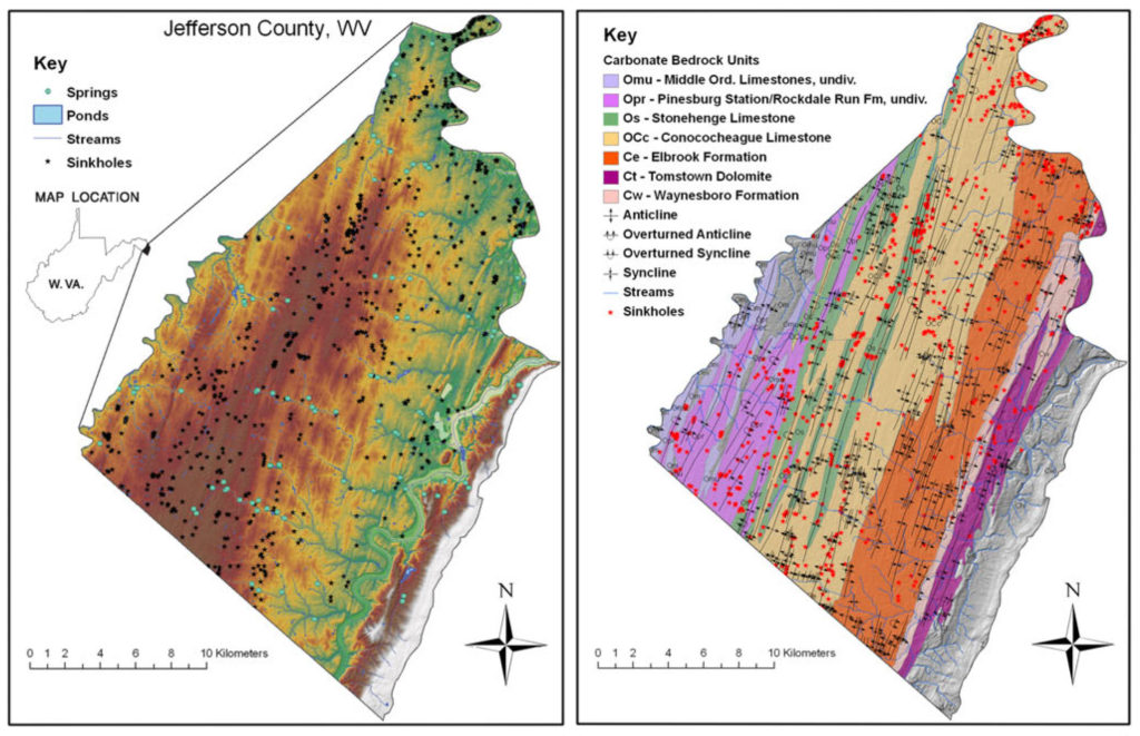
It has been well defined in the scientific literature that this portion of Jefferson County has karst hydrogeology (1, 2, 3, 4). A karst landscape is characterized by the presence of sinkholes, springs, caves, ridges and sharp projections in the underlying bedrock, and highly irregular soil-rock interface. The karst landscape is a consequence of the presence of soluble bedrock, which consists of limestone in the case of Jefferson County. The maps in Figure 1 show that the entire area in question is underlain by Conococheague or Stonehenge limestone commonly found in areas of advanced karst. In such landscapes water percolates through the ground and dissolves the underlying rock creating a porous network of caverns and throughways.
Karst aquifers are known to be “extremely vulnerable to pollution,” due to direct connection between the surface and underlying high permeability aquifers (5, 6, 8).
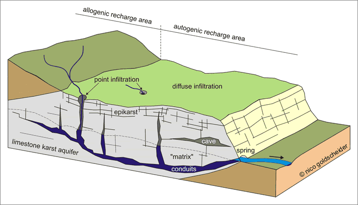
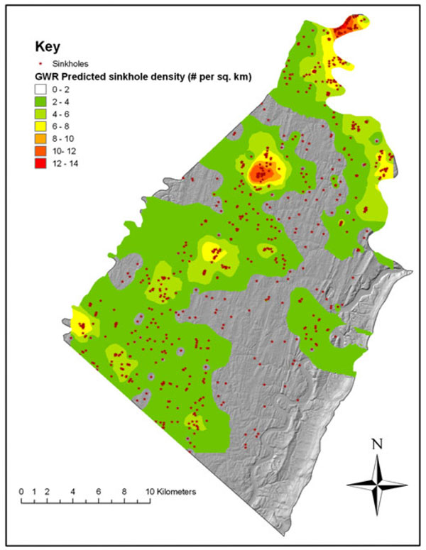
This particular site is on an upland area with relatively few surface streams, seasonal variability in the water table that results in numerous estavelles, and large amounts of water in the epikarst. This water is easily contaminated because of rapid diffuse infiltration of surface water into the ground water through the porous bedrock and point infiltration through sinkholes (Figure 2). This site has severe ground instability and a high rate of sinkhole formation. The springs at the margins of this upland area are directly affected by the water quality at this site (see the sinkhole map above). In this way pollutants could be carried from the surface at the cite into the groundwater effecting water wells and to surface water affecting several surface water streams and the Potomac River.
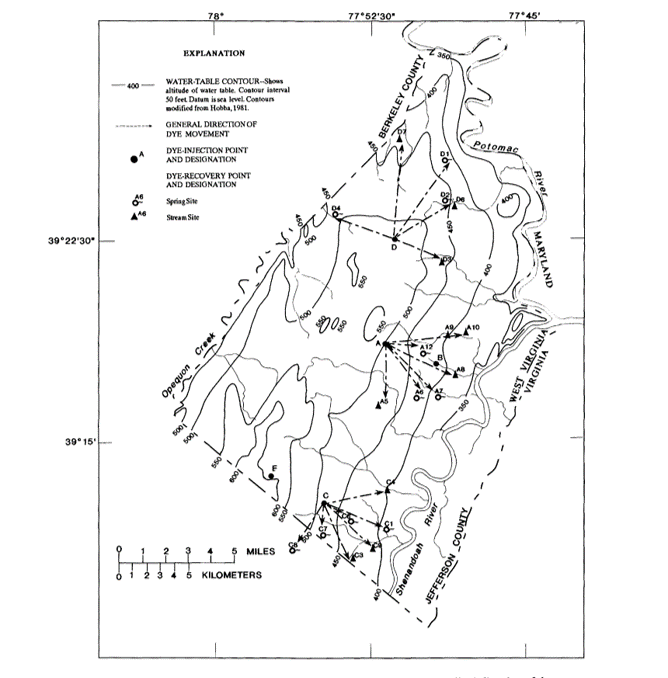
There are dozens if not hundreds of private wells within a mile of the site. In a dye test, the USGS found that the water from just adjacent to this site emerged in the headwaters of Shaw Run, Rocky Marsh Run, Town Run, Elk’s Run and Rattlesnake Run (1) (Figure 3). Rocky Marsh Run and Elk’s Run are important for municipal water sources, and all of these waters eventually enter the Potomac River which provides water to 6 million people east if Jefferson County.
A study demonstrated that in this area, several factors increased the rate of sinkhole development, including presence of surface water and development. Therefore, the large weighty buildings, drastic changes in ground contour, and centralized stormwater management that is typically required by heavy industry will actually make the karst situation worse, causing karst features to develop and progress more quickly. This was exemplified by the Rockwool construction project, where 22 sinkholes developed thus far during construction. In fact, the Rockwool site has a sinkhole density of more than 140 sinkholes per square mile! The same or worse would be expected in this location.
What does the West Virginia Department of Environmental Protection Say?
For decades now, policy makers have been using “Aquifer Vulnerability” measures, of which karst is very high, to set land use and water resource protection policy. (8) The guiding documents of the WVDEP recognize this. The introduction to the WVDEP document Stormwater Management Design in Karst Areas states, “it is important to note that the potential for geological hazards, damage to infrastructure, and groundwater contamination is an ongoing concern when developing in these areas. And that best approach is to craft stronger comprehensive land use plans that direct new growth away from karst areas to more appropriate locations.”(11) Again, the WVDEP guidance documents agree. The Chesapeake Bay karst stormwater guidance document (12), which WVDEP cites in the Stormwater Management Design in Karst Areas (12), clearly states “the working group notes that while communities that incorporate this guidance into their development review process can reduce the incidence of infrastructure damage and groundwater contamination, there is always some inherent risk when development occurs on this sensitive terrain. Consequently, the best local approach is to craft stronger comprehensive land use plans that direct new growth away from karst areas to more appropriate locations”. These policies recognize some types of land use can increase the amount of surface contamination and that in combination with high aquifer vulnerability the likely hood of ground water contamination is much greater. This is why industrial development in such locations is so inappropriate.
Contamination of the ground water in this location is both exceedingly likely and devastating. It is clearly exceptionally inappropriate to have heavy industry in this location in the county due to the hydrogeology and the potential for groundwater and surface water contamination.
See What the Expert Hydrogeologist Said About the Effects of Development in this location.
How Will These Environmental Impacts Effect the Economy of The County and Region
Due to the unique hydrogeology of the county the groundwater quality at the site rapidly effects groundwater, surface water streams, and the Shenandoah and Potomac River are affected by this location in the county. The majority of residents in Jefferson County rely on ground water, so contamination of the ground water would affect them severely. Ground water is also critical to the equine and agricultural industries, which are themselves critical to our local economy. The water quality of the Potomac and Shenandoah River is critical to the tourism industry in the county. Groundwater is difficult or impossible to remediate once it is contaminated. If fouled in this location this could have devastating long lasting effects on the ground and surface waters of the county and similar effects on our economy, health, safety, and well being.
Even Heavy Industry Knows This is a Bad Idea
In Rockwool’s own geotechnical investigation report prepared for Thrasher Engineering by Specialized Engineering, it states the following:
“Some sinkholes failures can be induced by construction activities and are of significance because the sinkholes can directly affect the site being developed, either immediately or some years later. Construction activities that can trigger sinkholes include 1) diversion or impoundment of drainage or dewatering activities, 2) removal of overburden cover, 3) shock vibrations, such as blasting, and 4) increased loading.
Prediction of sinkhole location or occurrence is difficult, if not impossible, and there is always a significant degree of uncertainty associated with the occurrence of future sinkholes. Structures built within the area of influence of a sinkhole can also be affected by sinkhole collapse or subsidence.
By virtue of the underlying geologic formation, the Owner must acknowledge there is an inherent risk of potential ground subsidence or collapse associated with construction of structures in karst terrain. All sites in karst terrain have the potential for sinkhole formation.” (10)
Even a firm employed by heavy industry recognizes the negative effects of development in karst and the dangers it imposes. This also demonstrates that we cannot trust heavy industry entities to “do the right thing”. This is why appropriate zoning is so necessary. We can’t trust business to do what government should. Business cares about money the government should care about the health and welfare of the people.
1. Kozar MD, Hobba WA, Macy JA, Geohydrology, water availability, and water quality of Jefferson County, West Virginia with emphasis on the carbonate area, US GEOLOGICAL SURVEY, 1991
2. Doctor DH, Doctor KZ. Spatial analysis of geologic and hydrologic features relating to sinkhole occurrence in Jefferson County, West Virginia. Carbonates and evaporites. 2012 Jun 1;27(2):143-52.
3. Doctor DH, Weary DJ, Brezinski DK, Orndorff RC, Spangler LE. Karst of the Mid-Atlantic region in Maryland, West Virginia, and Virginia. Field Guides. 2015 Sep 1;40:425-84.
4. Doctor DH, Weary DJ, Orndorff RC, Harlow, Jr GE, Kozar MD, Nelms DL. Bedrock structural controls on the occurrence of sinkholes and springs in the northern Great Valley karst, Virginia and West Virginia. In Sinkholes and the engineering and environmental impacts of karst 2008 (pp. 12-22).
5. Gutiérrez F, Parise M, De Waele J, Jourde H. A review on natural and human-induced geohazards and impacts in karst. Earth-Science Reviews. 2014 Nov 1;138:61-88.
6. Ford D, Williams PD. Karst hydrogeology and geomorphology. John Wiley & Sons; 2013 May 3.
7. Carpenter DL, Connelly DT, M Innis. Project Shuttle, Site Characterization Report VRP (Volunteer Remediation Plan) Parcel Jefferson Orchards Site. Environmental Resources Management. 2017 Sept.
8. Machiwal D, Jha MK, Singh VP, Mohan C. Assessment and mapping of groundwater vulnerability to pollution: Current status and challenges. Earth-Science Reviews. 2018 Oct 1;185:901-27.
9. Doerfliger N, Jeannin PY, Zwahlen F. Water vulnerability assessment in karst environments: a new method of defining protection areas using a multi-attribute approach and GIS tools (EPIK method). Environmental Geology. 1999 Dec 1;39(2):165-76.
10. Project Shuttle -New Industrial Site at the former Jefferson Orchard Kearneysville, Jefferson County, West Virginia Specialized Engineering Project No. 177164, Specialized Engineering 4845 International Blvd, Suite 104 Frederick, MD 21703, July 11, 2017
11. Appendix C: Stormwater Management in Karst Area, in West Virginia Stormwater Management and Design Guidance Manual, Center for Watershed Protection, Inc, 2012, Nov; C1-C4
12. CSN Technical Bulletin no. 1, Stormwater design guidelines for karst terrain in the Chesapeake Bay watershed, version 2.0, 2009
The Zoning Map Amendment IS NOT consistent with the objectives and policies of the Comprehensive Plan.
This land use does not conform to the Future Land Use Guide, it is outside the Urban Growth Boundaries, and outside of the Preferred Growth Areas, and therefore it should not be approved. While the Zoning Map can be amended by the County Commission for five reasons set forth in the Comprehensive Plan, these reasons include “environmental considerations.” This environmentally sensitive land should be protected under the current rural zoning. One major goal of the Comprehensive Plan is to protect farm land. This rezoning removes a large tract of land in the rural zone from rural agricultural land and does not use any of the measure set forth in the comprehensive plan to protect and promote agriculture and agricultural land.
More about the Comprehensive Plan (click to expand)
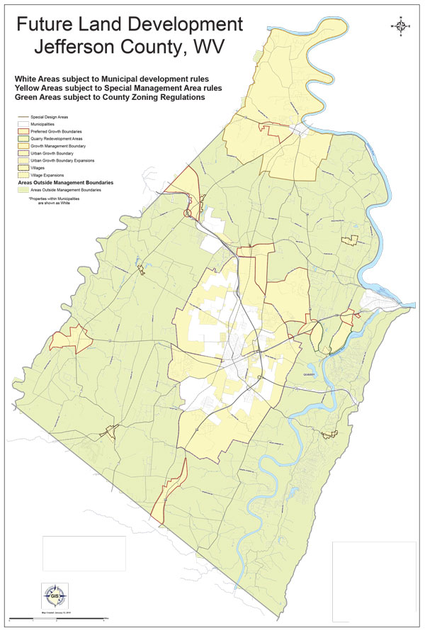
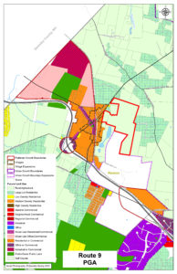
This zoning map amendment does not conform to the zoning map or the future land use guide. Jefferson Orchards argues that this land is in a preferred growth area however the Future Land Development Map of Jefferson County shows that this land is well outside of the Preferred Growth Boundaries and it does not even contact county land the preferred Grown Boundaries.
Under § 8A-3-4 of the WV code, one of the mandatory components of a comprehensive plan is the future land use map. The comprehensive plan states the:
“Use of the Future Land Use Guide is to be in combination with the recommendations of this Plan when considering owner initiated zoning map amendments. The purpose of the Future Land Use Guide is to assist in guiding the Planning Commission and County Commission in making decisions on changes to the Zoning Map.”
“All zoning map amendments shall be in conformance with the Future Land Use Guide and the recommendations of this Plan.”
Urban Growth Boundaries and Preferred Growth Areas are the “sections of Jefferson County where urban scale development is to be targeted over the planning horizon of Envision Jefferson 2035.”
“While limited development is possible based on the existing zoning regulations, the intention is not for urban scale development to take place in the Residential Areas and Rural/Agricultural Areas.”
This is rezoning is an owner initiated zoning map amendment and should conform to the Future Land Use Map. However, as you can see (Map to the side) this land that is to be rezoned is not in an area preferred for industrial use and residential use. This land use does not conform to the Future Land Use Guide, it is outside the Urban Growth Boundaries, and outside of the Preferred Growth Areas, and therefore it should not be approved.
In the Urban Level Development Recommendation (Goal 1) of the compressive plan it does explain how the County Commission can including Zoning Map Amendments in 5 cases including:
a. Economic Well-Being of the County; or
b. Error or Under Scrutinized Property on the Future Land Use Guide; or
c. Change in Neighborhood; or
d. Any Other Circumstance that the Governing Body determines should have been considered when drafting the Future Land Use Guide; and/or
e. Environmental Impacts are considered.
Jefferson Orchards is trying to argue that “a.” through “c.” should allow the County Commission to change the zoning. In short, they say that more industry and more houses will provide a large tax base, jobs, and consumers. They argue that this land should have been included in the urban growth boundary, and finally that there has been a change to the neighborhood because Rockwool was built there and there are now water, sewer, and gas there.
Read the Jefferson Orchards Zoning Map Application.
While the neighboring municipality may have changed and there may be utilities available now, this land as noted above is of exquisite environmental sensitivity due to its hydrogeology. This land should be set aside as a protected zone and it should remain as the rural agricultural land. Industrial land uses will increase the likelihood that stormwater will be polluted with industrial contaminants and contaminate the groundwater in this location. Please see the environmental section above to learn more about this.
The Comprehensive plan makes very clear that it prioritizes preserving agricultural lands stating: “One of the highest priorities of the Envision Jefferson 2035 Steering Committee and the public was the desire to preserve the rural landscapes, heritage, and lifestyle that attracted many residents to Jefferson County.” This is exactly the kind of agricultural land lose that the comprehensive plan aims to eliminate. Neither the residential nor the industrial portion of this rezoning conforms to this section of the comprehensive plan.
Read more about how the Comprehensive Plan prioritizes agriculture
Under Rural Land use planning the comprehensive plan states:
“Between 1974 and 2007, nearly 14,000 acres of land were removed from agricultural production in the County. Approximately 78% of these acres were lands with prime soils or soils of statewide importance. It is important that viable existing farmlands are protected. By encouraging cluster residential development, a large portion of the property will be maintained for farming activities, which would allow Jefferson County’s agricultural and rural character to be maintained.”
“One of the highest priorities of the Envision Jefferson 2035 Steering Committee and the public was the desire to preserve the rural landscapes, heritage, and lifestyle that attracted many residents to Jefferson County. Comments were received that indicated Jefferson County needs to balance the demands of growth with the protection of agricultural lands. Efforts of the agricultural and artisan communities can create desirable places for tourism to thrive. In these communities, visitors can visit working farms, shop at an artisan studio, and eat at restaurants that are either located on farms or that serve food derived from local enterprises.
The form and types of development that takes place in the rural environment should be respectful of the rural culture and historic nature of the community. Many of the residential and commercial structures built in Jefferson County are similar in design and scale to types of buildings constructed in other areas of the U.S. without consideration of local architectural style.”
Under Rural Land Use the comprehensive plan states:
In the Rural Land Use Planning Recommendation (Goal2) the fourth point states: “Protect the viability of agricultural lands and wildlife corridors by encouraging the utilization of cluster subdivisions as the preferred form of residential development within rural areas.” This development does not utilize this practice.
This Zoning Map Amendment DOES NOT conform to the purpose of the Jefferson County Zoning and Land Development Ordinance.
The Jefferson County Zoning and Land Development Ordinance sets forth 11 purposes of the legislation. This Zoning Map Amendment is contrary to seven of these purposes. The purpose of the legislation is clearly to use the comprehensive plan to grow the economy while protecting the environment and historic preservation and increasing the livability, and attractiveness of the county and in doing so, protect the health, safety and welfare of the people. On the contrary, this Zoning Map Amendment is contrary to the comprehensive plan and would adjoin vastly different land uses, decreasing agricultural and economic productivity of adjacent land, degrading historic sites, threatening widely used critical natural resources and the environment, and thereby threatening the health, safely, welfare and quality of life of a majority of residents in Jefferson County.
Read more for Jefferson County Zoning Ordinance Information (click to expand)
You can view the Jefferson County Zoning and Land Development Ordinance here.
Article 1: Section: 1.1 of the Jefferson County Zoning and Land Development Ordinance gives the purpose of the ordinance. Purposes A through K are given.
Purpose D. States: Ensure that growth and development are both economically and environmentally sound. And Purpose H. states: Encourage the conservation of natural resources. This zoning change will threaten both the ground and surface water in a large portion of the county. This water is critical to the Agriculture, Tourism, and Equine industries, and pollution of this water would have significant negative effect on the local economy. Therefore, this zoning change would endanger the natural resources of the county risking both the environment and the economy.
Purpose F and G state F. Encourage and support commercial, industrial, and agricultural activities while maintaining land use, order and compatibility, and G. Encourage an improved appearance of Jefferson County with relationship to the use and development of land and structures. Purpose K. states Encourage Historic Preservation. This Zoning Map Amendment would juxtapose industrial, residential and rural uses. This would lead reduced compatibility, order, and livability and more unsightly communities. This area has historic properties and such development would degrade these properties. This is precisely what the zoning is meant to prevent.
Purpose E states: Encourage the maintenance of an agricultural base in the County at a level sufficient to insure the continued viability of farming. This Zoning Map Amendment would remove a large continuous parcel that is contiguous with other large parcels of farmland from farmland use.
Purpose B. states: Help guide the future growth and development of Jefferson County in accordance with the adopted Comprehensive Plan. This Zoning Map Amendment is in conflict with the Comprehensive Plan. For more information on this see the section on the Comprehensive Plan above.
Finally Purpose A. states: Protect and encourage the health, safety, and general welfare of the present and future population of Jefferson County. This Zoning Map Amendment will threaten the natural resources of the county and thus will threaten the health, the safety and the welfare of the county residents. This Zoning Map Amendment is antithetical to 8 of the 11 purposes set forth in the zoning ordinance of Jefferson County and for this reason it should not be approved.
This Zoning Map Amendment DOES NOT conform to the West Virginia State Code on Zoning and Land Use.
The State Code sets forth seven issues that must be considered when enacting a zoning ordinance. This Zoning Map Amendment contradicts all seven of the considerations.
Read more for State Code Information (click to expand)
Chapter §8A-7-2. Contents of zoning ordinance states:
(a) The following must be considered when enacting a zoning ordinance:
(1) Promoting general public welfare, health, safety, comfort and morals;
(2) A plan so that adequate light, air, convenience of access and safety from fire, flood and other danger is secured;
(3) Ensuring attractiveness and convenience is promoted;
(4) Lessening congestion;
(5) Preserving historic landmarks, sites, districts and buildings;
(6) Preserving agricultural land; and
(7) Promoting the orderly development of land.
Because this section uses the word “must,” the county commission is required by law to consider these things it is not optional. This Zoning Map Amendment will remove land from agricultural use. It will juxtapose widely divergent uses including industrial, residential, rural, and historically significant lands, thereby reducing attractiveness, the orderly development of land and degrading historic sites and buildings. It will increase congestion in Kearneysville and on 480. Finally, and likely most important, it will endanger natural resources thus threatening the health, safety, and welfare of the residents. This land use in this location is antithetical to the required considerations of the State Zoning Code and must not be approved.
The §8A-7-3(d) of the West Virginia State Code states that “[e]ach zone will be subject to the same rules, regulations, standards and designations throughout the zone, unless specific provisions are made by the governing body in the zoning ordinance.” This eliminates “spot zoning”. Spot zoning simply is when the use of one parcel of land differs from the surrounding properties in that zone. This is exactly what is occurring here where one parcel is being allowed to have a different use – industrial – than all the surrounding land, which is rural. This is an egregious example of spot zoning.
This Zoning Map Amendment application is misleading and inaccurate.
The misleading and inaccurate information in the Zoning Map Amendment Application Addendum make it clear that this Zoning Map Amendment does not align with the Comprehensive Pan, is contradictory to the purpose of the County Zoning Ordinance, and in opposition to the state zoning code.
Read the point-by-point analysis (click to expand)
In the Zoning Map Amendment Application Addendum, the applicant, Jefferson Orchards, explain why the zoning of the land should be changed. Here we take this part of the application point by point and demonstrate the flaws in the information and reasoning.
Read the Jefferson Orchards Zoning Amendment Application.
This area is not in a preferred growth area and will cause congestion.
On Page 6 of 12 the applicant argues that in 2012, the Kearneysville area was designated a Preferred Growth Area. However, this is inaccurate. A very specific corridor that ran along Route 9 West from Kearneysville to the county line was denoted as a Preferred Growth Area. This land that is to be rezoned is well outside of that boundary and nearly completely surrounded by land zoned rural.
They go on to argue that this land is at a major interchange and therefore should be developed. Again, this is inaccurate. This land is actually well removed from the major interchange of 9 and 480. Traffic from this location would have to travel through the village of Kearneysville on 480. This would create congestion in the village of Kearneysville and possibly necessitate an upgrade the infrastructure in Kearneysville (§8A-7-2 (a)(4) requires congestion be considered). Alternatively, traffic would travel through Ranson on Northport Avenue to 115, past the elementary school back into Kearneysville and then to the interchange on 480, or down the barely paved unlined Boarder Road to 480 and the interchange. This latter route would be shared in part with the 100 heavy trucks a day for Rockwool. In any of these scenarios, one could see the congestion issues posed by this development and how it is not position close to the interchange.
The applicant claims that this development would “Allow[] for extension of water, sewer and natural gas from Ranson,” however, it is entirely unclear if that is even possible. By their own admission, this location is eight miles from Charles Town. Can CTUB even handle this much more sewage? In 2018 CTUB spilled raw sewage 1 in 9 days of the year. Why, with no plan to upgrade the system, would we plan to extend the system even more?
There is far more risk to the economy than potential benefit.
On page 7 of 12, the applicant argues section 2.a. of the Urban Level Development Recommendation of the Comprehensive Plan are met by this rezoning request. 2.a. states that Economic Well-Being of the County should be considered by the County Commission when making zoning amendment decisions. Here they argue that residential growth in the county has not been as fast as projected, so this development should be approved. This is a ridiculous argument. This residential development does not follow the recommendations for residential development in the Comprehensive Plan and it is ridiculous to say just because we need to build housing, we should just allow houses to be built anywhere or any way. In fact, the Comprehensive Plan recommends cluster developments in areas zoned for development and against industrial uses near residential uses.
Then, the applicant tries to argue that “Jefferson County suffers from a lack of land with sufficient infrastructure to serve light industrial development.” In fact, the Jefferson County Development Authority spends massive amounts of time and money trying to market and sell lots for light industrial use in the Burr Industrial Park. They have an entire staff and large volunteer board dedicated to doing this. Still, many of these lots sit empty or abandoned. This is a solution in search of a problem, and it certainly does not constitute the need for a zoning change.
In fact, the economy will be negatively affected if the industrial use of this land leads to pollution of the ground and surface water of the county.
There was not an error in the Comprehensive Plan.
On page 8 of 12 the applicant argues under 2.b. of the Urban Level Development Recommendation of the Comprehensive Plan that the Comprehensive Plan has made an error by focusing growth around municipalities, villages, and major intersection. However, the State Code §8A-7-2(a)(7) states that the zoning ordinance should promote “orderly development of land” and concentrating development around municipalities, villages, and major intersections does promote orderly development of land around transportation, conveniences and utilities. This property is situated tangentially away from these things. This will not be orderly development and it was not an error in the Comprehensive Plan.
If you build it, they will change the zoning.
Next, the applicant argues that because Rockwool was built, it significantly changed the neighborhood by bringing in roads and utilities, and therefore they should be allowed to change the zoning to take advantage of this. This is the most pressing point. Jefferson Orchards made an agreement with Rockwool in 2017 that it would exclude certain uses for 1,000 feet around Rockwool. To abide by this deed restriction agreement and still develop this land, Jefferson Orchard needs the zoning changed on this land. Jefferson Orchards would like the zoning changed so that it can abide by its self-imposed deed restrictions and more lucratively develop its rurally zoned land. By this reasoning, there is literally nothing to stop this progression of development across the heart of the county. It changed the neighborhood and now it wants to claim it should be given deference because the neighborhood changed.
Not multi-modal, not accessible.
On page 10 of 12 they again try to argue that this location has multi-modal transportation access. Again, this is just a complete misrepresentation. Jefferson Orchards state that the development would have “direct access to multi-modal pedestrian and bike trails.” Anyone who has ever tried to bike on 480 knows that it is like taking your life in your own hands to get through that train track bridge. Jefferson Orchard tries to claim that this land has access to the pike path on route 9. However, it is over a mile from the development and anyone biking this route would have to share the road and —worse yet — the bridge over Route 9 with 100 heavy trucks a day to and form Rockwool. This location is not reasonably accessible by multi-modal transportation.
Jefferson Orchards has not engaged stakeholders.
On page 11 of 12 claims that they fulfill goal 3 under Village Objective by encouraging the extension of utilities. However, this section of the Comprehensive Plan specifically suggests that the applicant collaborate with key village stakeholders. This does not mean the private for-profit utility owners who would be happy to extend their utilities to more paying customers, but the actual village residents. This has not been done.