
Ranson Seeks Residents’ Feedback on Comprehensive Plan 2034
View / Download Draft Plan
Submit a Public Comment on the draft comp plan
Update on the definition of industrial in the zoning ordinance
The City of Ranson hired a consulting firm to rewrite the Ranson Comprehensive Plan. This process happens only every 10 years and can impact the city of Ranson and surrounding communities for decades to come.
Jefferson County Foundation has reviewed the current draft and has outlined some of the possible problems particularly with the shoestring annexation portion of Ranson (near Kearneysville). This land is particularly sensitive due to the karst hydrogeology and is prone to sinkholes, which can cause pollution in the groundwater resources for the county and region.
Take Action!
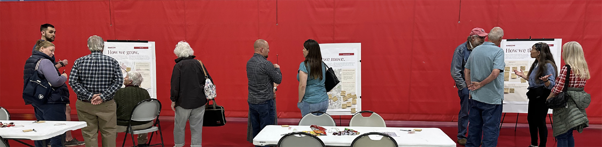
The Ranson City Council will hold a public hearing and the second reading and final vote on the Ranson Comprehensive Plan on April 9, 2024 at 7:00 p.m. at Ranson City Hall. Use our portal to add personal comments and send in to the Ranson City Council. We encourage residents—in Ranson and in surrounding areas—to take advantage of this opportunity to tell Ranson their thoughts on the proposed plan. If you live, work, shop, eat, play, or you or your business are affected by what happens in Ranson, your input is welcome—and needed! Please see our notes on the plan below and add your own comments.
We need to encourage the Ranson City Council to correct the issues with the Comprehensive Plan before adopting it. We understand this may take more time, but we think it’s worth it.
View / Download Draft Plan
Submit a Public Comment on the draft comp plan
Major Issues with the Draft
Environmentally sensitive land should be protected from polluting development.
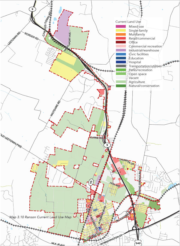
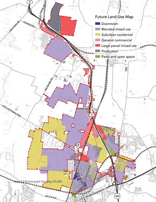
The agricultural land in the northern most shoestring annexation of Ranson (Jefferson Orchards, Inc.) near Kearneysville (see map below) was designated by the previous land use map as “new community.” In the newest draft land use map, this land is designated as “large parcel mixed use.” The term “large parcel mixed use” is ill-defined and too broad in the draft comprehensive plan. We are concerned that developers will use the broad nature of this definition to develop this land with polluting industry.
The narrative of the comprehensive plan indicates that “large parcel mixed use” should be similar to general business. However, general business is not a designation anywhere within the comprehensive plan. If instead Ranson intended to indicate that “large parcel mixed used” should be similar to “general commercial,” then the allowable zoning designations should be the same as “general commercial” and they are not.
“Large parcel mixed use” includes the zoning designation “light industrial.” The zoning designation “light industrial” does not currently exist in the Ranson zoning code. This could cause significant problems for interpretation of the Comprehensive Plan. We are concerned this will lead to development with more polluting industry.
Bringing more polluting industry to Ranson endangers the water resources that a large portion of the county and region rely on and puts vulnerable communities with no representation in Ranson at the greatest risk.
This environmentally sensitive land should be designated for preservation as open space.
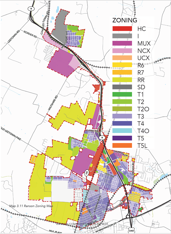
Compare the Three Land Use Maps
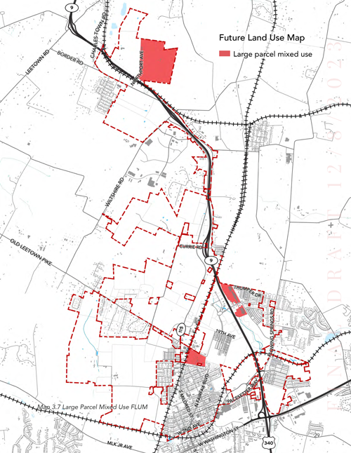
This environmentally sensitive land has been designated a “Preferred Development Area” effectively fast tracking the development of this land.
This draft changed the “Preferred Development Area” map and changed this environmentally sensitive land from second priority for development to third priority for development. However, the narrative still identifies this land as a preferred development area.
In the RENEWAL, DEVELOPMENT & FINANCE section of the draft plan this area of Ranson – the “northeast section of Ranson” – is designated for “Preferred Development.” In the narrative of this section, it states:
“On the east [of route 9], thanks to the infrastructural groundwork laid by Northpoint Avenue, Ranson stands poised to elevate its employment metrics. Focusing on light industries and warehousing here can result in a steady revenue stream, with the added benefit of generating jobs.
By channeling development efforts into these areas, Ranson can effectively maximize its return on investment. The immediate benefits come in the form of reduced initial costs, given the existing infrastructure.”
This is a short-sited approach; it’s also not transparent. Ranson did not actually invest anything in this development (in fact, it waved Rockwool’s inspection fees), and large scale development here will likely receive a tax abatement deal diminishing any financial gain the city would have seen from a new community. While this approach will allow the one land owner and the private utilities that serve this area to see maximum financial benefit, it completely neglects the effect on the environment and the negative effect on the health, safety, and welfare of residents and business owners in Ranson and the surrounding communities.
Why These Changes are Major Issues
Environmental
This change is dangerous because of the advanced karst nature of this land. It has highly sensitive groundwater resources that are easily contaminated by surface pollutants, and the groundwater from this location carries pollutants rapidly to groundwater and surface water (Elks Run, Rocky Marsh Run, Opequon Creek, and the Potomac River) in a large portion of the county and region.
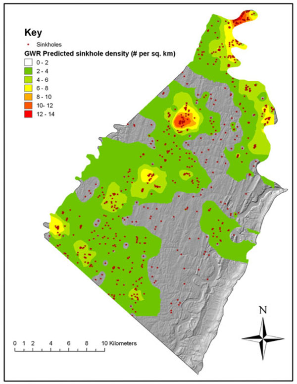
The West Virginia Department of Environmental Protection stated in its guidance on stormwater design in karst areas: “And that best approach is to craft stronger comprehensive land use plans that direct new growth away from karst areas to more appropriate locations.” This is guidance directly from the WVDEP, and this change in the draft plan is going directly against this guidance.
- The groundwater aquifer in this area is very near to the surface, the bedrock is very porous, and the sinkhole development risk is high. Surface water and any pollutants that are in it, rapidly travels into the groundwater through the porous bedrock and sinkholes (which provide a direct conduit from surface to groundwater).
- USGS studies have shown that the water from this site travels rapidly (two weeks or less in some cases) to at least five watersheds to the north, west, and east of the site affecting a large portion of the groundwater and surface water in the county.
Injustice
This change is amoral because it puts vulnerable communities with no representation in Ranson at highest risk. Several of the immediately adjacent communities to this area of Ranson are some of the most economically disadvantaged and diverse communities in the state of West Virginia according to the EPA Environmental Justice website. Further industrial development of this area of Ranson close to these vulnerable communities is environmental injustice. What is worse is that because of the shoestring nature of these annexations the people who live the closest (by far) and will be affected the most can’t even vote in Ranson and will not benefit from the taxes Ranson raises on these developments.
Economic
This change is not the economic development Ranson needs and it endangers current businesses. Research has demonstrated that small local businesses and startups provide better compensation and contribute significantly more to the local economy then large outside businesses that provide lower pay and take profits out of small communities like ours. These large out of state corporations typically demand long tax abetment deals shifting the tax burden to maintain infrastructure and the like to existing local businesses making it harder for small businesses and startups to survive, and they often drive median incomes down. Read more here.
By endangering the water resources this development endangers the agricultural, equine, and tourism businesses that are the backbone of our local economy and rely on these resources.
Bad Precedent
This change sets a bad precedent because the land owner is seeking the change because of voluntary restrictions it placed on the land.
Jefferson Orchards, Inc. already sought to have this land rezoned for industrial development. The planning commission voted to not recommend this change because the rezoning did not agree with the comprehensive plan. This drastic change in the comprehensive plan land use map would likely accommodate that land owners request.
Why does the land owner want the zoning changed? As a condition of sale when they sold the adjacent land to Rockwool, the owner voluntarily placed a deed restriction on the land that does disallows a new community from being developed there. Now instead of leave the land in agriculture or natural area the land owner is seeking to change the zoning to accommodate this voluntary deed restriction and increase the value of the land for itself.
We should not set a precedent that land owners’ game the system to get the zoning they want by putting a deed restriction on their land. (see below for more information)
Not Consistent with the Plan narrative, Goals, or Actions
This change is not consistent with the narrative of the comprehensive plan. The plan states, “This chapter identifies constraints to development, such as flood- prone and subsidence areas, and set out strategies to mitigate risks associated with these issues.” And “However, like many small cities, Ranson faces challenges such as managing population density, balancing growth, and mitigating constraints to development like flood-prone and subsidence areas.” Yet the plan changes the designation of this land that had a high sinkhole risk to allow polluting industrial development there.
The plan states, “Agricultural lands lie predominantly on the periphery, preserving the rural heritage and providing a buffer between urban and rural lands.” Yet this change would but industrial development right up against farmland and historic homes with no buffer. This plan says one thing and does another.
- The land across from Rockwool that was retained by Jefferson Orchards, Inc. when it sold part of the orchard to Rockwool is currently zoned for open green space and new mixed-use communities. The new land use map would allow the land to be developed into heavy industrial uses like Rockwool.
- The Land Use section of the comprehensive plan states repeatedly that land that floods and land with subsidences should be protected. However, in the future land use map, the land with the most sinkholes and sinkhole risk (subsidences) is designated for heavy industry development. This land needs to be protected from industrial development to protect the groundwater resources of the Region.
- The designations of “Production” and “large parcel mixed use” are ill-defined and too broad in the draft comprehensive plan. “Production” seems to include heavy industrial uses like Rockwool.
- A great majority of the land designated for “Production” and “large parcel mixed use” or heavy industrial uses is in the northern-most shoestring annexation section of Ranson. There are several major issues with this:
- This is the most environmentally sensitive land in Ranson. Allowing industrial development risks the water resources of a large portion of the County and larger region.
- This land is immediately adjacent to underserved, diverse, and economically disadvantaged communities in the county and state. It is simply unethical and an environmental injustice for Ranson to put polluting industry far away from its own citizens in these communities while reaping the benefits of this business (taxes) for its own good. The people who actually live in the surrounding communities cannot vote in Ranson and will not benefit from the taxes Ranson collects on the industrial development. The consultants explained to us that this was a good location for industrial development because the pollution would not affect the “Ranson Residents.” What about the county residents?
- This is not the kind of development Ranson needs. Research shows that small town economies benefit more from small local businesses and startups then large polluting industrial out of state corporations.
Update on the definition of industrial in the zoning ordinance
At the last Ranson City Council meeting, the Ranson City Council decided to incorporate some of the changes that Jefferson County Foundation was requesting. While the ordinance is certainly not perfect, it is more protective than when they started.
The Foundation has decided strategically not to seek further changes to the ordinance before it’s adopted. We believe that is more important for the ordinance to be adopted prior to the adoption of the comprehensive plan. We are concerned that if this does not occur that Jefferson Orchards will try to have its zoning designation changed before the zoning ordinance could be amended (i.e. when the comprehensive plan is approved and when the ordinance could be approved). For these reasons, we will not oppose or seek further change in this zoning ordinance at this time.
Tell Ranson – Suggested comments you can personalize and submit through our portal
Very important! Add a personal message to the body of the public comment about why this is important to you and your family or business! Type in that information and click “send email now” and your message will go directly to the Ranson City Council and the Planning Commission.