
Karst Hydrogeology:
The Risk to Water Resources
Heavy Industry Endangers Vulnerable Water Resources
The Jefferson Orchard site, and much of the surrounding land in Jefferson County, should not be rezoned for heavy industry, or any industry that produces toxic or hazardous emissions. The hydrogeologic characteristics of this portion of Jefferson County make it ill-suite to heavy industry. Water contamination from such activities at this site is not an obscure hypothetical, but quite likely. This is an unacceptable risk to ask the people and economy of Jefferson County to bear for the profitability of the few. Further, if the groundwater is contaminated in this location, tens of thousands of people stand to be affected from Jefferson County to the Chesapeake Bay. Despite this information being readily available when originally rezoning, Ranson does not seem to have taken it into account.
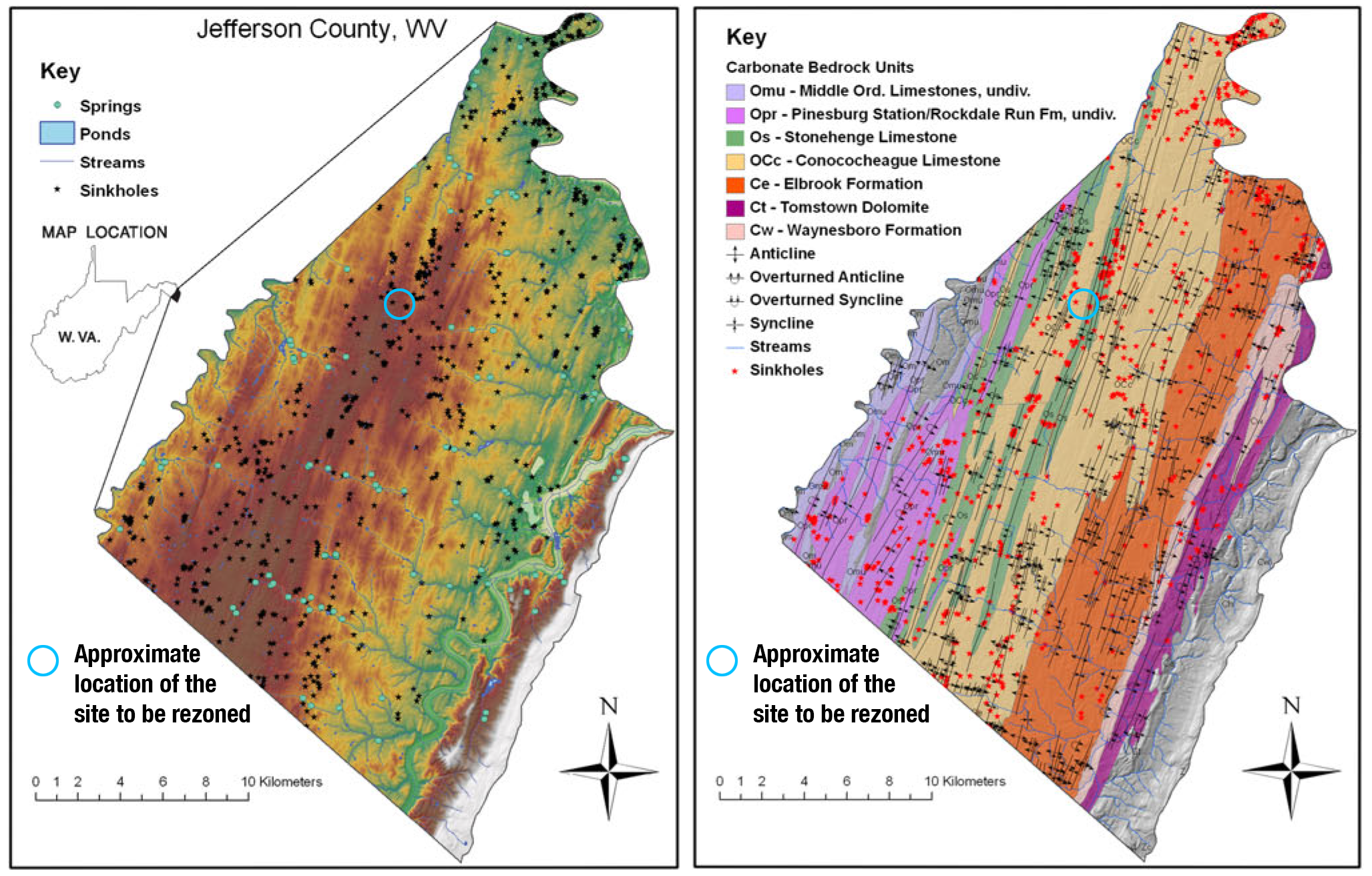
It has been well defined that this portion of Jefferson County has mature karst hydrogeology (1, 2, 3, 4). A karst landscape is characterized by the presence of sinkholes, springs, caves, ridges and sharp projections in the underlying bedrock, and highly irregular soil-rock interface. The karst landscape is a consequence of the presence of soluble bedrock, which consists of limestone in the case of Jefferson County. The maps in Figure 1 show that the entire area in question is underlain by Conococheague or Stonehenge limestone commonly found in areas of advanced karst. In such landscapes, water percolates through the ground and dissolves the underlying rock creating a porous network of caverns and throughways (Figure 2).
How You Can Help
Educate yourself and others
Read the detailed information on our website and share with others. Knowledge is power.
- The Background on Zoning in Ranson
- Karst Hydrogeology Concerns
- Heavy Industry Near Schools
- Negative Effects On Local Economy
- Heavy Industry Incompatible With Ranson’s Comprehensive Plan
- Environmental Discrimination
Donate to support our efforts
If you are able to, please support our ongoing legal efforts with a fully tax deductible donation.
How Do Sinkholes Form?
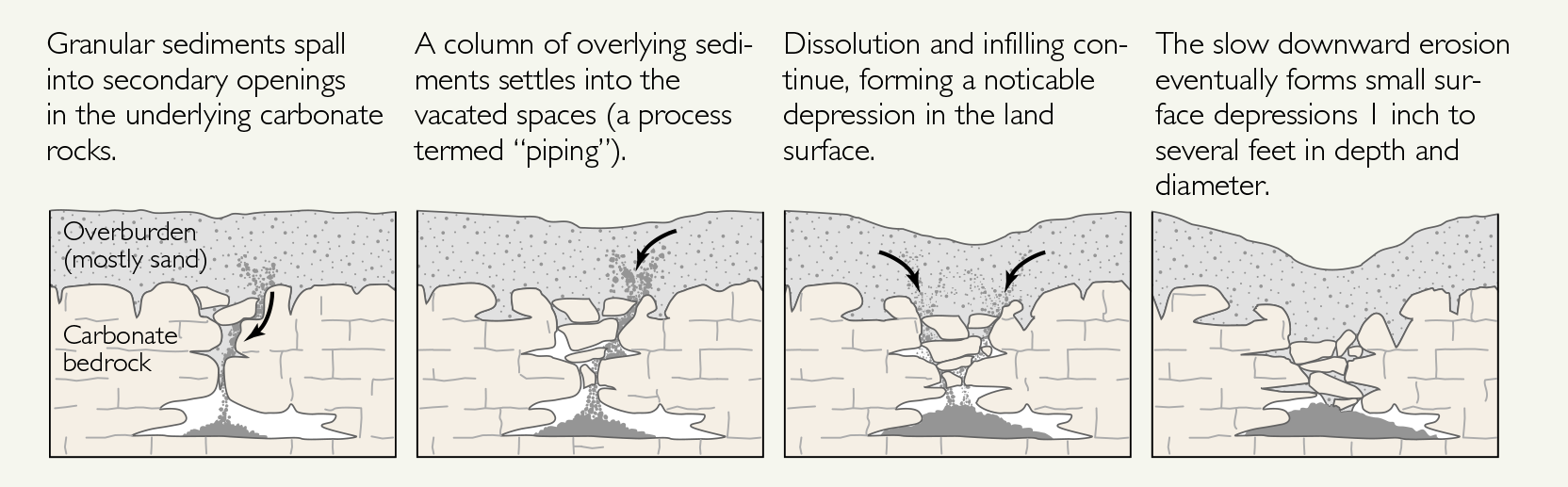
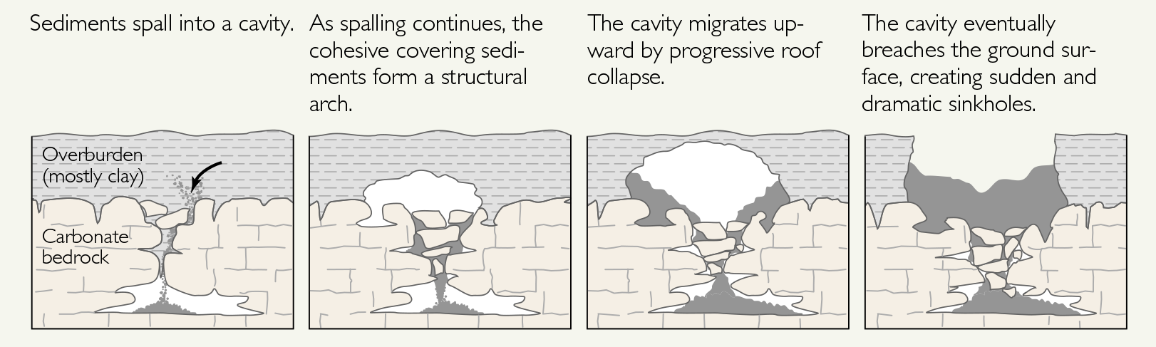
Figure 2: Source, Land Subsidence in the United States, USGS, Public domain
Karst aquifers are known to be “extremely vulnerable to pollution,” due to direct connection between the surface and underlying high permeability aquifers (5, 6).
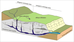
The site is on a karst feature known as an “Arabian plain.” (Figure 3) This is an upland area with relatively few surface streams, seasonal variability in the water table that results in numerous estevelles, and large amounts of water in the epikarst. This water is easily contaminated because of diffuse infiltration of surface water into the groundwater through the porous bedrock and point infiltration through sinkholes (Figure 4). The springs at the margins of the Arabian plain are directly affected by the water quality throughout the aquifer.
The groundwater at this site is only 60 feet below the ground (7), and it is known from dye studies that this water moves through the ground and back to the surface relatively quickly (Figure 5).
The North Jefferson Elementary School’s and Fox Glen Utilities’ Wellhead Protection Areas both intersect with the site. The Walnut Grove Utilities’ Wellhead Protection Area is within half a mile and the USDA Appalachian Fruit Research Wellhead Protection is within one mile of the site. There are dozens if not hundreds of private wells within a mile of the site (Figure 6).

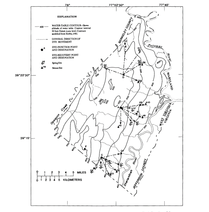
In a dye test, the USGS found that the water from just adjacent to this site emerged in the headwaters of the Elk’s Run and Rattlesnake Run and Shepherdstown Town Run (1) (Figure 7). The Elk’s Run headwaters is a spring about three miles south east of the site and goes on to become the drinking water source for Harpers Ferry and Bolivar before emptying into the Potomac River (Figures 1, 3 and 6). The Town Run in Shepherdstown is a stream that runs right through the middle of town where children play and learn to fish. The headwaters of Rattlesnake Run is a spring about 3.5 miles from the site and is also a tributary of the Potomac River.
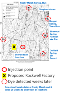
These are just three of the examples the dye test demonstrated of how the groundwater at the site communicates with and affects the surface waters in the county. This site is also in the Rocky Marsh Run watershed, which is in the source water protection zone for Shepherdstown and drains to the Potomac River. Therefore, activity at this site will affect both groundwater and surface water streams.
Karst hydrogeology has very high “aquifer vulnerability” due to the diffuse and point infiltration (8). Karst is known to have “severe ground instability problems” (9). This makes karst geology prone to sinkhole development. Sinkholes provide direct connection between the surface water and any contaminants it may contain and the groundwater through point infiltration. As shown in Figure 2, sinkholes may develop quickly and the ground surface may show no signs of a sinkhole prior to collapse. This particular site is located in the area with the largest sinkhole density in Jefferson County (Figure 8) (1, 2, 3, 4).
A study demonstrated that in this area, several factors increased the rate of sinkhole development, including presence of surface water and development. Therefore, the large weighty buildings, drastic changes in ground contour, and centralized stormwater management that is typically required by heavy industry will actually make the karst situation worse, causing karst features to develop and progress more quickly. This was exemplified by the Rockwool construction project, where 19 sinkholes developed thus far during construction. In Rockwool’s own geotechnical investigation report prepared for Thrasher Engineering by Specialized Engineering, it states the following:

“Some sinkholes failures can be induced by construction activities and are of significance because the sinkholes can directly affect the site being developed, either immediately or some years later. Construction activities that can trigger sinkholes include 1) diversion or impoundment of drainage or dewatering activities, 2) removal of overburden cover, 3) shock vibrations, such as blasting, and 4) increased loading.
Prediction of sinkhole location or occurrence is difficult, if not impossible, and there is always a significant degree of uncertainty associated with the occurrence of future sinkholes. Structures built within the area of influence of a sinkhole can also be affected by sinkhole collapse or subsidence.
By virtue of the underlying geologic formation, the Owner must acknowledge there is an inherent risk of potential ground subsidence or collapse associated with construction of structures in karst terrain. All sites in karst terrain have the potential for sinkhole formation.” (10)
Even a firm employed by heavy industry recognizes the negative effects of development in karst and the dangers it imposes. This also demonstrates that we cannot trust heavy industry entities to “do the right thing.” This is why appropriate zoning is so necessary. We can’t trust business to do what the government should. Business cares about money; the government should care about the health and welfare of the people.
“By virtue of the underlying geologic formation, the Owner must acknowledge there is an inherent risk of potential ground subsidence or collapse associated with construction of structures in karst terrain.”
Specialized Engineering, hired by Thrasher Engineering, the firm retained
by Rockwool
A simple search of the peer reviewed literature reveals a plethora of information highlighting the risks associated with development in karst geology and many techniques for studying the impact of development on such land. It does not appear as though the municipality of Ranson employed any of these methods when it incorporated or rezoned this area.
For decades now, policy makers have been using “Aquifer Vulnerability” measures, of which karst is very high, to set land use and water resource protection policy. (8) The guiding documents of the WVDEP recognize this. The introduction to the WVDEP document Stormwater Management Design in Karst Areas states, “it is important to note that the potential for geological hazards, damage to infrastructure, and groundwater contamination is an ongoing concern when developing in these areas. And that best approach is to craft stronger comprehensive land use plans that direct new growth away from karst areas to more appropriate locations.” (11) Again, the WVDEP guidance documents agree. The Chesapeake Bay Karst Stormwater Guidance document (12), which WVDEP cites in the Stormwater Management Design in Karst Areas (12), clearly states “the working group notes that while communities that incorporate this guidance into their development review process can reduce the incidence of infrastructure damage and groundwater contamination, there is always some inherent risk when development occurs on this sensitive terrain. Consequently, the best local approach is to craft stronger comprehensive land use plans that direct new growth away from karst areas to more appropriate locations”. These policies recognize some types of land use can increase the amount of surface contamination and that in combination with high aquifer vulnerability the likely hood of ground water contamination is much greater. This is why heavy industry in such locations is so inappropriate.
Through direct and diffuse infiltration to the aquifer and Rocky Marsh Run activity at this site will affect both ground and surface water streams. The majority of residents in Jefferson County rely on ground water, so contamination of the ground water would affect them severely. Groundwater is also critical to the equine and agricultural industries, which are themselves critical to our local economy. The water from Rocky Marsh Run and the other streams like Elks Run and Rattlesnake Run that are fed from springs contiguous with the Arabian plan aquifer under the site, eventually flow to the Potomac River. The Potomac is the drinking water source for many communities in Northern Virginia and Maryland. Just like all of the water in Jefferson County, this water eventually flows to the Chesapeake Bay. In this way, pollution at the site affects the water of a much greater region.
Contamination of the groundwater in this location is both exceedingly likely and devastating. It is clearly exceptionally inappropriate to have heavy industry in this location in the county due to the hydrogeology and the potential for groundwater and surface water contamination.
Endnotes
1. Kozar MD, Hobba WA, Macy JA, Geohydrology, water availability, and water quality of Jefferson County, West Virginia with emphasis on the carbonate area, US GEOLOGICAL SURVEY, 1991
2. Doctor DH, Doctor KZ. Spatial analysis of geologic and hydrologic features relating to sinkhole occurrence in Jefferson County, West Virginia. Carbonates and evaporites. 2012 Jun 1;27(2):143-52.
3. Doctor DH, Weary DJ, Brezinski DK, Orndorff RC, Spangler LE. Karst of the Mid-Atlantic region in Maryland, West Virginia, and Virginia. Field Guides. 2015 Sep 1;40:425-84.
4. Doctor DH, Weary DJ, Orndorff RC, Harlow, Jr GE, Kozar MD, Nelms DL. Bedrock structural controls on the occurrence of sinkholes and springs in the northern Great Valley karst, Virginia and West Virginia. In Sinkholes and the engineering and environmental impacts of karst 2008 (pp. 12-22).
5. Gutiérrez F, Parise M, De Waele J, Jourde H. A review on natural and human-induced geohazards and impacts in karst. Earth-Science Reviews. 2014 Nov 1;138:61-88.
6. Ford D, Williams PD. Karst hydrogeology and geomorphology. John Wiley & Sons; 2013 May 3.
7. Carpenter DL, Connelly DT, M Innis. Project Shuttle, Site Characterization Report VRP (Volunteer Remediation Plan) Parcel Jefferson Orchards Site. Environmental Resources Management. 2017 Sept.
8. Machiwal D, Jha MK, Singh VP, Mohan C. Assessment and mapping of groundwater vulnerability to pollution: Current status and challenges. Earth-Science Reviews. 2018 Oct 1;185:901-27.
9. Doerfliger N, Jeannin PY, Zwahlen F. Water vulnerability assessment in karst environments: a new method of defining protection areas using a multi-attribute approach and GIS tools (EPIK method). Environmental Geology. 1999 Dec 1;39(2):165-76.
10. Project Shuttle -New Industrial Site at the former Jefferson Orchard Kearneysville, Jefferson County, West Virginia Specialized Engineering Project No. 177164, Specialized Engineering 4845 International Blvd, Suite 104 Frederick, MD 21703, July 11, 2017
11. Appendix C: Stormwater Management in Karst Area, in West Virginia Stormwater Management and Design Guidance Manual, Center for Watershed Protection, Inc, 2012, Nov; C1-C4
12. CSN Technical Bulletin no. 1, Stormwater design guidelines for karst terrain in the Chesapeake Bay watershed, version 2.0, 2009
13. City of Charles Town Construction Stormwater General Permit Registration Application, Stormwater Pollution Prevention Plan, 2019